A long distance through trip that crosses the main divide from east to west. Most people would probably want to allow 4 or 5 days for the trip which is evenly split with 50km of trekking and 50km of paddling. Some off-track navigation is required and the class III Gentle Annie gorge has no easy exit so it’s for competent parties. There are several possible alternative walking approaches, via Lake Christobel or the Doubtful Valley. If you just want to paddle then the Upper Grey is directly accessible from Palmer Road – but you bought a packraft because you also enjoy walking right?
Thanks very much to Richard Dove for the words and map, and ProjectStory/Olivia Spencer-Bower for the photographs.
The Shuttle
It’s a long one! Leave a car on Waipuna Road just south of Ikamatua on SH7. There are parking spots just off the main highway or head further upstream to reduce the final paddle out. Head back through Springs Junction and Lewis Pass to the NZDA lodge (90 minutes).
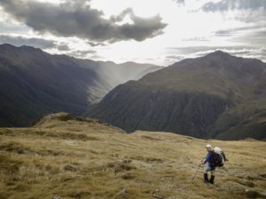
Highway to Nina Hut and Upper Nina Biv
From NZDA Palmer Lodge in the Lewis Pass cross the swingbridge and head up the Nina valley. A good track initially follows the true left of the Nina before crossing after about an hour via a swingbridge to the true right to continue to the Nina Hut (10 bunks). 3 hours DOC time. If you’re not staying at Nina Hut then a lesser track (not marked on topo maps but marked and easily followed on the ground) stays on the true left the whole way and avoids a short detour to the hut.
From the Nina Hut follow the track back down to the river which is crossed to the true left (meeting up with the lesser track). A reasonable track goes to Upper Nina Biv (2 bunks) 2 hours DOC time further upstream.
Upper Nina Biv to Top Robinson Hut
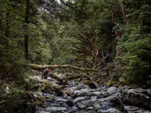
There’s no track but reasonably good going either in the Nina riverbed or on the flats alongside. We followed the main river until the 5th side stream entering from the true right which heads towards the saddle at pt1452 just north of Mt Boscawen. Make sure you get the correct side stream as this is the key decision point (the 4th side stream was dry when we were there). You can’t see the saddle from the Nina River bed. Travel up the riverbed of the side stream was straightforward to the tussock basin tops and then on to the saddle.
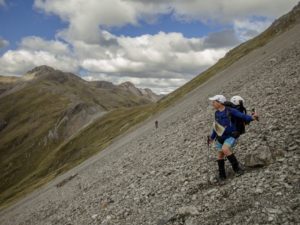
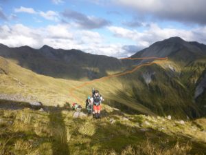
From the saddle sidle across the northern slopes of Mt Boscawen on scree of varying size at around 1450m before heading down the NW spur to pick up the marked route from Lake Christabel to the Robinson River. After a short climb the track then plunges 800m to the Robinson River, crosses a walkwire then shortly after reaches Top Robinson Hut (8 bunks). It’s a long steep descent with fairly light marking but once underway it sticks to the crest of the spur.
Time from Upper Nina Biv to Top Robinson Hut around 7-8 hours (maybe 10 hours DOC time if they gave one).
Top Robinson Hut to Mid Robinson Hut
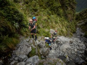
A fairly straightforward track downriver although a bit overgrown and lightly marked. Mid Robinson Hut (6 bunks) is reached after 6 hours DOC time.
Mid Robinson Hut to Upper Grey junction
Continuing downriver on the same track there are a few sections where windfall has covered the track. After the final swingbridge and just before the track heads off to meet Palmer Road it disappears into an impossible mess to round the final point. We couldn’t follow the track and nor could another party we met, but the riverbed is easy travel instead. Stay in the riverbed or on the terraces to the Upper Grey rather than following the track to Palmer Road. Around 6-7 hours DOC time. With more water in the river the Robinson River could probably be paddled from the Mid Robinson Hut – we were there mid summer and it was too low to bother. If paddling look out for trees in the river, there were a few ugly points.
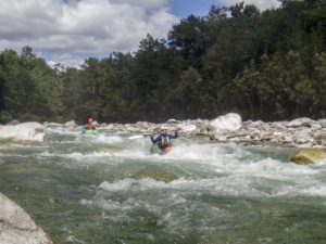
Grey River (I/II) Upper Grey to Gentle Annie Gorge
Time for some paddling! With no recent rainfall the Upper Grey added considerably more water than the Robinson. The first 12km or so to McVicars farm (marked on topo maps) is shingle riverbed, mostly single channel. With low river levels there were a few spots too shallow to paddle but it was straightforward class I to II paddling. Again look out for trees, we had to portage one corner that was completely choked. There are plenty of camping spots along the way up until McVicars which marks the start of the gorge. Much of the flats in this valley are farmed; be sure to camp in the bush edge rather than out in the middle.
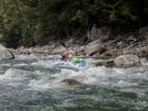
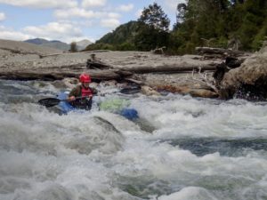
Grey River (III) Gentle Annie Gorge
A very scenic gorge with alternate rapids and calm pools. At low river levels the rapids were long boulder gardens with plenty of quite tight maneuvering required. There are lots of good eddies and holes to either avoid or play in. Some scouting may be warranted but everything ran fine for us. Make sure somebody is comfortable at class III and up to help with those decisions as it would be a long stressful paddle if you’re in over your head. Once in the gorge there is no easy escape route, although most rapids could be portaged if desired. Some more water would probably make the rapids easier, to a point.
Keep an eye on the map as the initial long gorge is followed by a couple of shorter gorges each with some good rapids. After the Clarke confluence, the paddling eases to class II.
River flats to Highway 7 (I)
A straightforward paddle out to the highway. This section dragged a bit but even at low water it was all deep enough to paddle. You leave your car higher up Waipuna Road if desired to avoid this section.
Total paddle time from the Grey/Robinson junction to Highway 7 was around 8 hours.
Gauge
Grey River at Waipuna (West Coast regional council)
We paddled at 25 cumecs. Inland Adventures rafts this section commercially and were happy to be contacted about safe levels (Nathan ph 0508 723846)