


The upper run from Maling Pass to Hanmer Springs
The Upper Waiau Uwha in North Canterbury is a classic multi-day wilderness river trip through the St James Conservation Area. Expect braided flats, tawhai clad slopes, tussock top views, and an engaging and challenging river. It has a remote feel and stunning scenery. This is a serious backcountry mission for experienced paddlers. Bang for buck this trip rates very highly – it’ a Kiwi Classic! Truly one of New Zealand’s most rewarding wilderness river trips—a rare combination of remote alpine scenery, exciting whitewater, and superb camping.
This trip is best suited to experienced paddlers with solid Class III+ skills and good backcountry judgment. It can be completed in two paddling days, but most parties prefer three to savour the scenery and enjoy the exceptional camping. Whilst Labour weekend, with lively spring flows, is ideal for kayakers and rafters early summer is a safer bet for packrafters. November is often the sweet spot for packrafters, less subject to high flows but still with some snow melt.
In January 2018, The Waiau Uwha was renamed from the previous ‘Waiau’ – there are many Waiau rivers, and this traditional name acknowledges the history and mana of the river, as well as distinguishing it from other great paddling rivers like the Waiau Toa (Clarence) and Wairoa (which was previously called Waiau, that flows from Lake Manapouri)
Access
From Hanmer take the road over Jacks Pass Rd and continue up the Waiau Toa (Clarence) valley on Tophouse Road. At the Waiau Toa bridge there is a parking area and a locked gate to the Maling Pass 4WD road (get an access code/key from DOC) The walk follows a rough 4WD track and takes two or so hours depending on fitness and how efficiently you carry your gear. Where the Maling Pass 4WD track reaches the river, you can put in. A reasonable 4WD shuttle with good ground clearance and low ratio should get you all the way to the put-in. Sometimes the road can be closed (storm damage, horse musters) so check in early in advance of your trip.
For the take-out, head west from Hanmer Springs along SH7 to Calf Creek and scout the 4WD access road to the river – spotting the take-out from the water without prior knowledge is difficult as it’s a little upstream of where you might expect. Some paddlers choose to continue downstream to take out and walk a short distance up the Hanmer River to a rest area for an extended trip.
Shuttles – there are a few options in Hanmer Springs for shuttles. Hitching in summer would be a gamble but not impossible.
On the Water
The trip can be divided into a number of sections
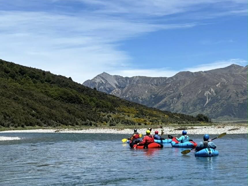
Waiau Uwha Ada (II): Braided flats below Maling Pass to Henry confluence (18km)
Waiau Uwha Three Gorges (III+): Three short gorges and boulder gardens to Peninsular Campsite (7km)
Waiau Uwha McArthurs (II+): A brief respite from the intensity (10km)
Waiau Uwha Narrows (IV): The Narrows – portage recommended for packrafters (2km)
Lower-upper Waiau Uwha (II+): Below The Narrows to Hope River (17km), Handysides (another 5km) or Hanmer River (another 22km)
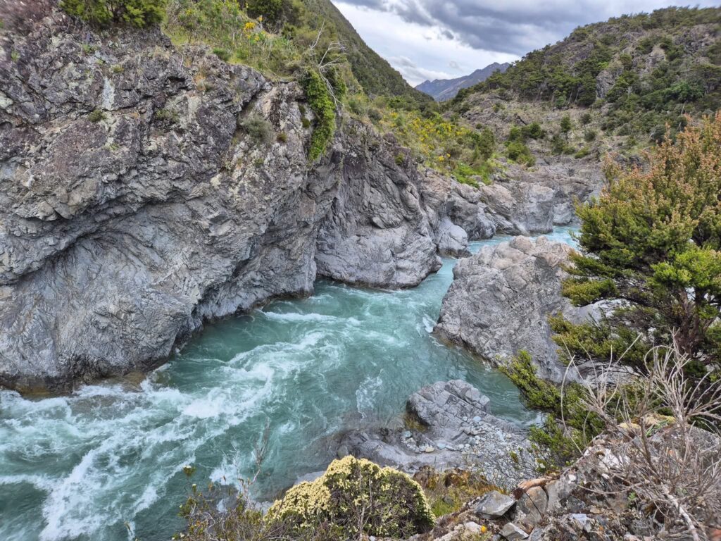
From the put-in, the river initially flows over a shingle, stony bed with a braided character and shallow channels. The first three hours to the Henry River confluence are a perfect warm-up and a chance to get in the zone while soaking up the views of the surrounding Spenser Range. This section is all about relaxation and anticipation, as the river meanders through open valleys with braided channels and crystal-clear water. You might even spot a semi wild St James horse. Below Ada Flat, the river begins to close in, and the character changes dramatically.
Upper River Character (Jule Harle)
Things start to get interesting about 2 km below the Ada River confluence just below Delta stream. Here, the Waiau Uwha encounter a bedrock block (care of the Fowler Fault) and the channel tightens and begins to deliver busy Class III boulder gardens between rock walls.
Top Gorge – the Kick Down begins (Jule Harle)
The Top Gorge entry rapid is unnamed but it forces you to wake up and kick down your gears for maximum acceleration – or risk the other kind of bruising kick down. It is a busy Class III+ boulder garden that culminates in a bedrock chute. It’s the first real test of the trip, just shy of 100m, and quite continuous. It’s a good idea to climb on river left to observe the entry rapids as they are quite the step up from the mellow upstream section. The entry rapid is quickly followed by another shorter Class III.
After a kilometre of easier paddling the intensity builds again with rock gardens as you approach the second bedrock gorge.
The Saddle Spur swing bridge marks the start of the second gorge which again starts with a burly Class III and maintains intensity with a few more over about 800m.
Coming out of the second short gorge the river bed is boulder strewn and there are numerous rock garden/ graveyard pool drop rapids. The first and most consequential is the steep and continuous Rock Garden rapid. The rocks in this rapid move around and it may be the most technical challenge of the trip. It will go Class IV in higher flows. This should be carefully bank-scouted. Talk it through as a group and think about safety as there are a lot of places to swim!
Scouting “Rock Garden” III+/IV (photo Wendy Sullivan)
After this long sequence of boulder garden rapids the river eases a little, but there are still plenty of Class III rapids and play-waves to keep you entertained, especially if flows are good.
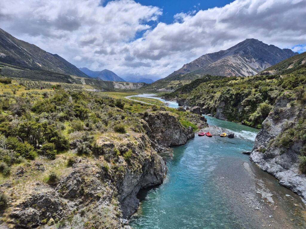
In the third gorge, there are half a dozen good rapids. The last rapid of note is III+ and rapid and at some flows can present a river wide feature you can’t walk around – if it doesn’t work out the pool at the bottom provides opportunity for recovery.

Peninsular Campsite (Jule Harle)
Below the Third Gorge there is good camping on a river terrace on river left – the Peninsular campsite. It’s a flat grassy site sheltered by mature matagouri and manuka. There are lots of geomorphological features that speak to the valleys recent glacial history to marvel at from camp. As the sun sets you’ll discover this is dark sky country making for idylllic evenings under the stars. These camps are some of the best you’ll find on any New Zealand river trip. But do take insect repellent!
Please also remember that fires are not permitted in the St James Conservation area – it would be a massive challenge to put out a wild fire in this dry valley.

Dark sky country (Jule Harle)
The alternative to camping, though high above the river, is Pool Hut (4 bunks). It is best accessed by beginning at the McArthur bridge then following the track north for about 5 minutes.
Mc Arthur Section (photo Wendy Sullivan)
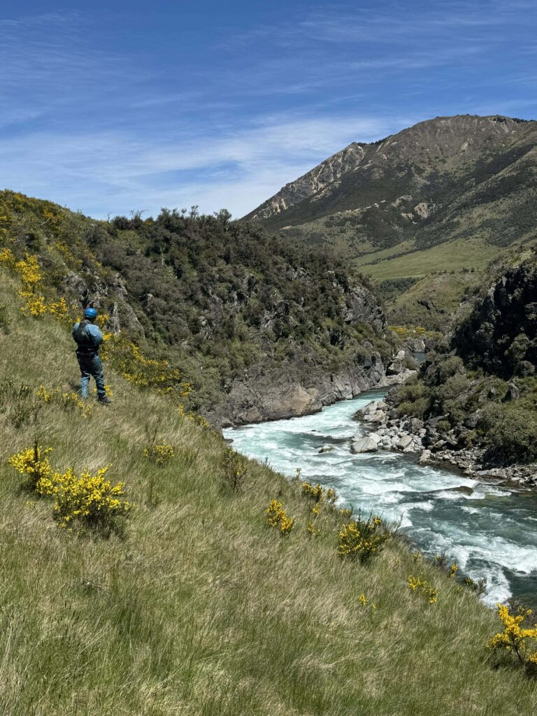
The river mellows to easy Class II as the river valley opens out and flows under the McArthur swing bridge – a perfect warm up for the second day of paddling! Almost ten easy kilometres of Class II water spiced with the occasional wave train, leading you toward the most renowned section of the trip -The Narrows (IV) – a bedrock gorge (no doubt formed by the Clarence Fault which crosses the valley on the upstream side).
The Narrows (IV)
This description of the Narrows is for when the river is at low – medium flow. The lead-up to the Narrows is signalled by a couple of class III rapids and the view of the river entering an obvious constriction. Be conservative and scout on the right – a swim could be hard to recover from. There are two approach rapids before the fully committing Narrows section. The first is straight-forward but the second approach rapid is a large rock outcrop in centre stream that has laterals and buffer waves that increase in difficulty at higher flow (Egarr referred to the second rapid as The Squeeze). You should scout this approach section (on river right) so you understand where to Eddy out on river right to scout / partial portage the Narrows proper. See Section Below Portaging the Narrows.
Scouting the Approach to the Narrows (photo Wendy Sullivan)
The Narrows (IV) proper begins with The Weir. At low flow it can be a drop but at higher flow it slams into the left-hand wall creating a powerful churning boily, sometimes retentive, hole with wall buffer waves under an overhanging wall.
At low flows, this was traditionally run by kayakers on river right, but because it is quickly followed by another significant rapid (The Cauldron), packrafters choose to portage. The Cauldron is very turbulent churn with potential for undercuts downstream.
At low to medium flows it is possible to scout and portage the two most significant drops in the Narrows and put in below by seal launching on river right immediately after the Weir and Cauldron rapids. Please note that this approach will mean you are committed to running the boily water in the lower part of the Narrows. Note that exiting/ portaging from half way down the Narrows would be hard on your gear as steep terrain and matagouri both feature.
The water in the Narrows has lots of vertical movement in it. There are small eddies to stop and help team members who have had difficulties.
The tight and churny section culminates in Chockstone – at lower flow an easy line left of an obvious sieve (the rock is also a real hazard for big rafts). At higher flowers (say 8cumec at Maling) it may require an aggressive ferry to the left.
The rest of the Narrows is easier II–III, but the commitment factor remains high.
Portaging the Narrows
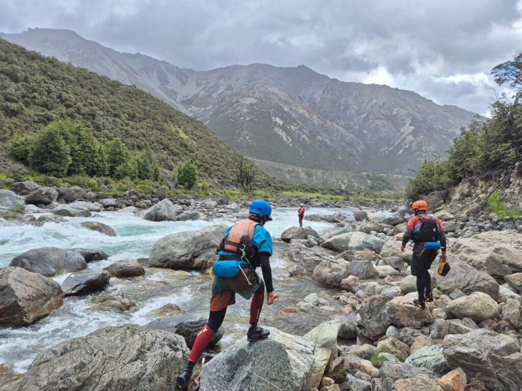
Portaging the entire Narrows is common for packrafters. Get out well upstream of the approach rapids to find the track (on river right) heading for Tin Jug Hut and beyond. If you leave it too late you’ll be bush bashing Matagouri – never good with drysuits and packrafts (though the portage is long enough to require deflation and packing). A GPS will help you in your search for the 4WD track which takes you away from the river. Once at Tin Jug Hut, walk down Steyning Creek to return to the river and put on.
Sage advice from paddling ace Sandra Hyslop “ if you were OK running everything on the upper gorge near the Henry it’s probably easier (partially) portaging this way (river right) than around the whole narrows section, but if you’ve done any portaging upstream it’s probably worth just going around the whole thing”. Or succinctly from Alaska’s Jule Harle “you gotta know when to hold em and know when to fold em”. A good reminder to weigh the risk vs reward for all the big rapids on this trip!
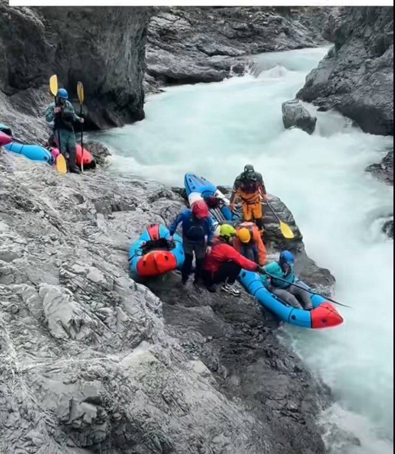
Portage of the Weir (first drop in distance) and the Cauldron (undercut behind paddlers) (Jule Harle)
The easiest partial portage of the first few Narrows rapids is on river right, with an assisted re-entry into the gorge immediately after these main rapids, or a longer carry downstream to throw the boat and jump (risky at higher flows). The re-entry is fast, turbulent and boily think through your strategy.
Below the Narrows (II+ some III)
After The Narrows, Steyning creek enters river right and you can collect any team members who chose ti portage vis Tin Jug Hut. The river relaxes into Class II–II+ with three class III rapids in the next 5km depending on flow. The valley remains narrower than upstream but the rapids have a similar character, with plenty of wave trains, rocks and boulders.
Many parties camp just below the gorge or use Tin Jug Hut, then enjoy a three- to four-hour paddle out the next morning or a much fuller day to Hanmer River. There is also some excellent camping on the river right about 7km below Tin Jug Hut – the land belongs to Glen Hope Station and if you wish to camp there a quick call to the farmer to ask permission is needed in advance.
Once you reach the Hope River confluence, cross to true right to find the 4WD take-out, or continue downstream for a longer trip taking out at the Hanmer river on river left – watch out for jet boats on the braided section.
The scenery remains spectacular, and anticipation of a different kind builds as you drift toward the take-out contemplating a hot pools visit and a pint in town. Be mindful of commercial jetboat activity near the take-out.
Land Tenure
The Valley down to Tin Jug Hut is public land administered by DOC. From Tin Jug hut (approx.) river right is private land. And from Boko Stream river left is private land. Respect private land.
View Larger Topographic Map
Gauge
- < 5 – scratchy and marginal for all but keen to carry packrafters
- 5 cumecs – good to go
- 7.5 cumecs – perfect
- 10 cumecs – burly
- 15 cumecs – hold on to your hat – the domain of ace kayakers
The Waiau is usually about 60% of the combined flow with the Hope at Marble Point. Bear in mind after a big westerly storm, the Hope may have more water, and after a big southerly, the Waiau will probably be higher.
- 40 cumecs – scratchy trip for keen summer paddlers (see Chris Coutts video)
- 80 cumecs – perfect (the level for Jule Harle’s trip as seen in photos)
Season
Paddling season is spring

Plot of a typical years flow – baseflow exceeds 5m3 at Maling from September to late November
Heres a video from Chris and Thomas Land who had a flow of 40 cumecs at Marble point, which is a fair bit lower than Kayakers would usually go for.
Typical Itinerary
- Day 1: Walk in via Malings Pass after a shuttle or Camping at Lake Tennyson
- Day 2: Paddle the Three Gorges to Peninsular Campsite or Pool Hut.
- Day 3: Paddle the McArthur’s section to the crux – The Narrows – portage or partial portage then camp below the Narrows or at Glenhope Station’s Tin Jug Hut (+64 3 315 7697 to ask permission to stay).
- Day 4: Paddle out to Hope River or Hanmer Bridge.
Trip Options – there are so many!
- Maling Pass 4wd track walk-in from Lake Tennyson – the usual trip
- Fowlers pass a longer more interesting walk in that cuts the upper Class II section as taken by Chris Coutts and Thomas Land
- Tin Jug Hut via Boyle (driving in with the Glenhope team is possible)
- Down the Edwards (visiting Cow Stream Hot Pools)
- Dan Clearwater’s epic route over the tops from Lewis Pass. (Foley’s Track to the Tops by Trovatore and down to the Henry River).
- A very long walk via Waiau saddle from Nelson Lakes.
- Exit before the Narrows and walk to Waiau Toa via Cow Stream Hot Pools and Paddle to the coast Like Deane Parker’s Bikerafting epic
Sources WWNZ and Graham Charles (NZ Whitewater). Egarr’s South Island Rivers, Hugh Canard, Polly Miller, Chris Coutts, Dan Clearwater, Mark Oates, Deane Parker, Jule Harle and many others. Compiled in an update in 2025 by Martin Robertson
Walked in over Maling Pass. Upper braids were not too scrapey at 90cms actually quite enjoyable ~3hrs paddle to Pool hut. A lot of rain overnight with river peaking at 200cms. I waited til midday when it had dropped to about 150 and think it was about 140 when I reached the narrows. Scouted and portaged Upper part over rocks on RR. 1st big drop looked doable but second hole looked quite retentive. Bit of a Bush bash on the portage (I packed up the boat for it) but got in to run the lower part of the narrows. I’d say if you were OK running everything on the Upper gorge near the Henry it’s probably easier portaging this way than around the whole narrows section, but if you’ve done any portaging upstream it’s probably worth just going around the whole thing. Epic paddling from the narrows down at these flows, and stunning gorges. An awesome trip! I was going to paddle to the Hanmer bridge but got a bit cold and bored so took out at a lay by next to the highway about 10km down from the Hope confluence and hitched back to my car. All flows off the Marble Point gauge.
We did this trip in April 2017.
Cruised up Foley’s Track from Lewis Pass to Camp on the Tops by Trovatore. After a frosty start, we had a fine day to traverse the ridgedline through to the Henry Valley for our second night.
The initial sections of paddling were pretty full on. With very continuous sections of grade 3 and a few grade 4’s (which myself and a few others portaged). After lunch it chilled out a bit, but there were still plenty of solid rapids that kept us scanning horizon lines and eddy hopping all day. The Marble point gauge was at 77 cumecs when we started paddling.
We began day 4 with a portage (via 4WD track) of the Narrows, then put on again at Tin Jug Hut. The final day still had regular grade 3 rapids, though most of the gorge sections were quite managable.
A spectacular and challenging trip with a great bunch of folks! Not to be underestimated!
photos here: https://www.facebook.com/daniel.clearwater.50/media_set?set=a.10158540560195463.1073742005.870605462&type=3